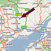
How to Find us

If you use a SatNav, the post code is NP4 0TA.
WARNING 1 This might not bring you to the correct place, you need to STAY ON SLUVAD LANE and go down to the dam.
WARNING 2 If you try to follow Google Instructions from the M4 they take you a hard and tortuous way. You need to stay on the main dual carriageway for one more roundabout (at the bottom of the hill at New Inn). This will miss out 2 unnecessary hills and a single track road with occasional passing places
See further directions here on this page.
Directions from M4 Westbound.
- Exit at J25a, A4042 to Cwmbran, at the first and second roundabouts turn right following the A4042. You then go straight over the next three roundabouts still following the A4042. At the next roundabout (at the bottom of the hill) turn right, towards New Inn. There are brown tourist signs to Llandegfedd Reservoir.
- Follow the road up the hill, curve left past the Lower New Inn Pub, and after 200 yards turn right on the corner. After a further 100 yards turn right along Sluvad Lane. Follow the lane for about a mile, past the treatment plant at the top of the hill, and down the hill and over the dam.
- The reservoir entrance is located on the left hand side at the far end of the dam. Tell the Rangers or Cafe staff you are coming to Llandegfedd Sailing Club.
- The first building you come to is the Visitor Centre. It serves food and drinks. A few hundred yards further on is the Watersports Centre. Parking is on the hill behind the Watersports building. Follow the road to the right and go up the hill a little way to get there.
Directions from M4 Eastbound.
- Exit at J26, A4051 to Cwmbran, straight on through the sets of traffic lights following the A4051. At the first roundabout turn right (3rd exit) signposted A4042 Abergavenny, then after 300 metres turn left on the A4042.
- You then go straight over the next three roundabouts still following the A4042. At the next roundabout (at the bottom of the hill) turn right, towards New Inn. There are brown tourist signs to Llandegfedd Reservoir.
- Follow the road up the hill, curve left past the Lower New Inn Pub, and after 200 yards turn right on the corner. After a further 100 yards turn right along Sluvad Lane. Follow the lane for about a mile, past the treatment plant at the top of the hill, and down the hill and over the dam.
- The reservoir entrance is located on the left hand side at the far end of the dam. Tell the Rangers or Cafe staff you are coming to Llandegfedd Sailing Club.
- The first building you come to is the Visitor Centre. It servers food and drinks. A few hundred yards further on is the Watersports Centre. Parking is on the hill behind the Watersports building. Follow the road to the right and go up the hill a little way to get there.
Directions from M50 Southbound.
- Drive to the western end of M50, and continue on following the A40 past Monmouth.
- Exit the A40 23 miles after the end of the M50 signposted Usk.
Go through Usk village, and continue over the river Usk bridge. Turn left at the end of the bridge, and then after approx 700 metres turn first right signposted Llandegfedd. This is a fairly narrow country lane, single width at times. - Keep on this road for a little over 3 miles until you come to the T junction in the village of Coed-y-Paen. Turn right and the reservoir is located on the right hand side of the bottom of the hill before you go over the dam. Tell the Rangers or Cafe staff you are coming to Llandegfedd Sailing Club.
- The first building you come to is the Visitor Centre. It serves food and drinks. A few hundred yards further on is the Watersports Centre. Parking is on the hill behind the Watersports building. Follow the road to the right and go up the hill a little way to get there.
Other Tools
You can also use the tools below by clicking on the links to get a new page.
Use Multimap
Use Google For Google Earth (We are shown here, but are actually located a bit further along on the reservoir roads).


